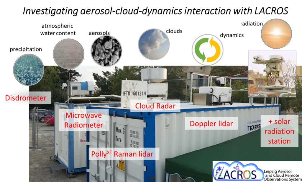
Fig. 1: Exploiting the synergies of the LACROS instruments for the simultaneous, co-located, vertically resolved characterization of the key parameters involved in aerosol-cloud-dynamics interaction. Courtesy: Patric Seifert, Johannes Bühl.
The Leipzig Aerosol and Cloud Remote Observations System LACROS
The Leipzig Aerosol and Clouds Remote Observations System (LACROS) is a combined aerosol and cloud remote-sensing mobile facility. It consists of cloud radar, Raman and Doppler lidars, and additional instruments for passive and active remote sensing. The co-located, continuous observations enable the development and application of sophisticated retrieval algorithms by exploiting instrument synergies (Fig. 1). The mobile exploratory platform has been already deployed for observations at the TROPOS sites in Leipzig and Melpitz as well as in field experiments at global hotspots, such as Cyprus and Southern Chile.
Fig. 1: Exploiting the synergies of the LACROS instruments for the simultaneous, co-located, vertically resolved characterization of the key parameters involved in aerosol-cloud-dynamics interaction. Courtesy: Patric Seifert, Johannes Bühl.
Motivation
The large number of unsolved questions concerning the interaction between aerosol particles and clouds and corresponding indirect effects on precipitation and radiative transfer demand new measurement strategies to resolve the atmospheric processes involved. In this regard, obtaining synergistic information about cloud and aerosol properties from multi–instrument and hence multi–sensor observations is a key approach to overcome the current lack of knowledge. Motivated by these needs, the mobile multi–instrument exploratory platform LACROS is being operated by the Department of Remote Sensing of Atmospheric Processes at TROPOS.
Instrumentation
LACROS comprises a unique mobile set of active and passive remote-sensing instruments. The sensors cover the wavelength ranges from the UV to microwave radiation and do thus allow to characterize aerosol, clouds and radiation.
The state of instrumentation of LACROS as of November 2021 is illustrated in Figure 2.
Active sensors are:
Passive sensors comprise
Passive instrumentation which helps to interpret the active remote measurements consists of an Aerosol Robotic Network (AERONET) Sun photometer, the microwave radiometer HATPRO that includes also two infrared radiometers, and an all-sky imager.
Meteorological surface data and radiosondes are available in addition in the framework of field campaigns. Measurements of a radiation-balance station that fulfills the criteria of the Baseline Surface Radiation Network (BSRN) are available. For the determination of precipitation properties an optical disdrometer records the velocity and size distribution of falling hydrometeors in the size range from 0.1 to 10 mm at 4 m above ground.
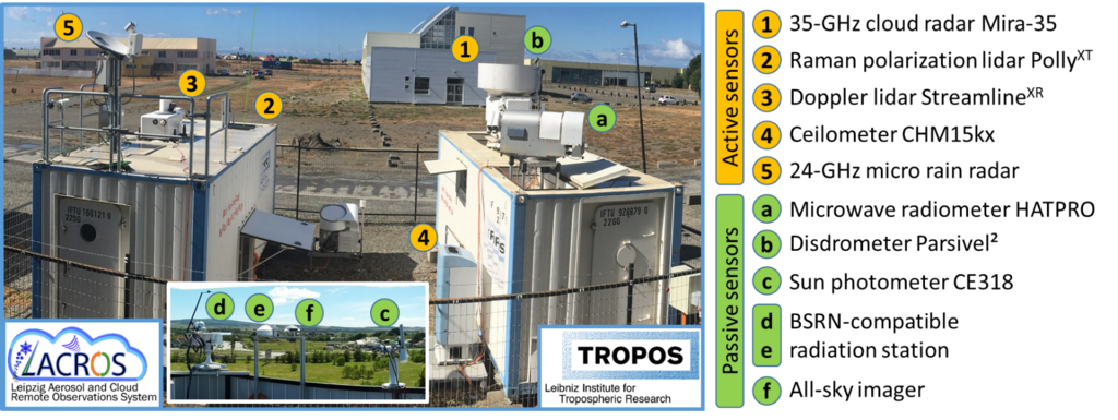
Fig.1: Instrumentation of LACROS as deployed during DACAPO-PESO (https://dacapo.tropos.de) in Punta Arenas (Nov 2018 – Nov 2021). Photo: Martin Radenz.
Fields of Application
The available lidar systems measure the optical and microphysical properties of aerosols and optically thin clouds, vertical winds within aerosol layers and at cloud base, as well as temperature and humidity profiles. The integration of the cloud radar into LACROS overcomes the limitation of the lidar systems to observe only cloud-free and thin-cloud (cirrus, altocumulus) scenarios. It enables extensive insights into the microphysical and dynamical processes of thick stratiform and convective clouds, and thus the investigation of droplet activation and precipitation formation in convective cloud systems. This achievement will facilitate novel links between atmospheric measurements, laboratory studies, and modeling activities. The current application of LACROS concentrates on four main subjects:
Investigation of heterogeneous ice–formation processes by exploiting co–located remote–sensing observations of aerosol and cloud radiative and microphysical properties.
Instrument validation and development of algorithms and new measurement techniques for ground–based cloud and aerosol microphysics retrievals in the frame of the Aerosols, Clouds, and Trace gases Research InfraStructure Network (ACTRIS). Current activities concern the development of a dual–field–of–view lidar technique to derive cloud droplet size information, on retrievals of aerosol microphysical properties from combined lidar and Sun photometer measurements, the retrieval of mixed-phase cloud microphysical properties such as the shape, number concentration and size of ice crystals, and the development of a framework to measure vertical air motions and the fall velocity of hydrometeors separately.
In this context, the Cloudnet algorithms have been implemented at TROPOS.
Cloudnet already provides a framework for the determination of cloud microphysics from remote-sensing observations, but further extensions are needed to improve reliability and availability. Cloudnet thus builts the basis for more sophisticated algorithms as the ones listed above.
The steadily growing number of spaceborne sensors for cloud and aerosol characterization also implies a need for ground–based observing stations that provide data sets for the validation of the derived products. Also, the combination of ground-based and spaceborne measurements may allow to reduce the uncertainties in the retrieval of cloud and aerosol microphysical properties.
Get involved
LACROS is operated as a mobile exploratory platform within ACTRIS. On the one hand, this ensures that the set of instruments and their observables undergo permanent quality assurance measures, which are developed, implemented and supervised within the community. On the other hand, the ACTRIS participation enables users to obtain access to the services of LACROS. This access can be realized physically on-site, remote, or virtual. It spans from co-located deployment of instruments, calibration or evaluation activities, utilization of the expert services of the LACROS team, up to arrangements of customized deployments of LACROS at user-defined locations. From April 2021 through March 2025, trans-national access is being offered via the European-Union program ATMO-ACCESS. More information about TNA services offered by TROPOS can be found on the ATMO-ACCESS webpage or here.