50th PollyNET Site
Leipzig, 04.09.2025 – Holger Baars
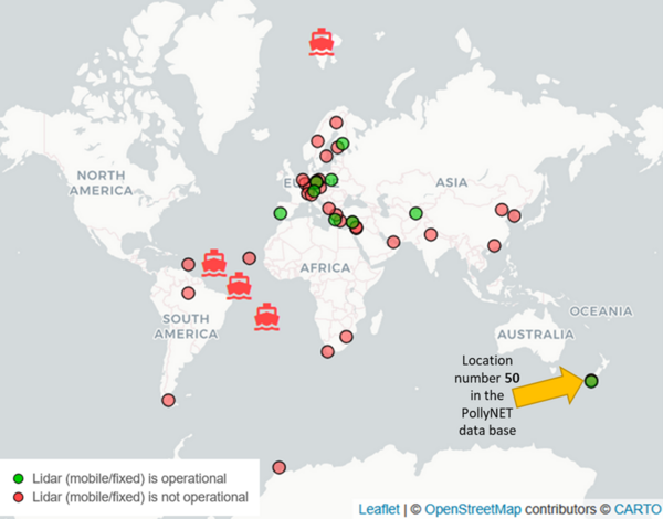
PollyNET celebrates its 50th location of active measurements
On 22 August 2025, first light was emitted to the atmosphere above Invercargill, New Zealand by the brand-new Polly system installed within the LACROS facility. Being established in the early 2000s, it is the 50th site of PollyNET at which a Polly lidar system has been deployed, meanwhile covering all continents.
PollyNET is a voluntary scientific network of lidars of type Polly using standardized lidar setups and quality procedures and a common processing chain. Several institutions are member of PollyNET.
PollyNET lidars are operated at permanent locations but also temporary sites and have meanwhile be performed in almost all climate zones, covering the harsh polar condition (Arctic and Antarctic), but also tropical rain forest (Amazon), deserts (United Arab Emirates, Central Asia), marine environments (e.g. RV Polarstern or Meteor) and urban metropoles (like the Pearl River Delta, Haifa, New Delhi). Several permanent stations (Evora, Kuopio, Leipzig, Dushanbe, Hohenpeißenberg, Limassol, Antikythera, Warsaw, Cabo Verde) also serve as working horse for EARLINET and ACTRIS. All these observations led to several scientific results and also contributed significantly to the global collection of aerosol intensive properties and to validation of space-borne lidar measurements. Almost 200 peer-reviewed articles have been meanwhile published based on PollyNET data.
By today, 15 Polly systems have been constructed at TROPOS, several together with the PollyNET partners. While the first Poly lidar was a two channel Raman lidar, measuring at 532 nm only, the latest version just deployed at Invercargill is a multiwavelength-Raman-polarization lidar with 18 channels, three telescopes, emitting 3 wavelengths, and able to perform water vapor and fluorescence measurements and retrieving cloud properties via the dual-field-of-view method. All PollyNET observation are processed in near-real time (PollyNET Processing Chain) and publicly shown at polly.tropos.de.
The anniversary measurements in New Zealand started just now and are taken in the framework of the goSouth-2 campaign to investigate the clean southern ocean atmosphere but also its vulnerability to aerosol advection from other sources.
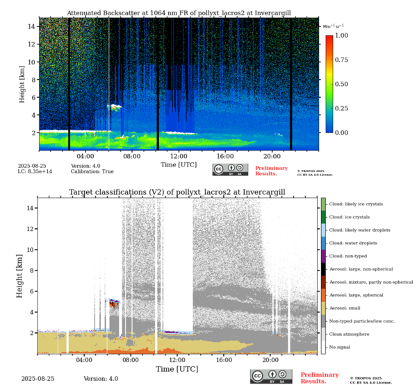
As an example, the very first 24 h measurement performed in Invercargill is shown below for the 25 of August 2025. The time-height plot of the attenuated backscatter coefficient and the automatic retrieved target categorization is shown.
As there is a 12-hour time shift to UTC, the plots start in the middle of the day, showing a dense liquid water cloud deck at around 2 km altitude until local evening (6 UTC). Afterwards, the clouds dissolved and revealed thin aerosol layers up to 7 km altitude above Invercargill. Thus, on this day, no pristine atmosphere was present but aerosol was advected most probably from Australia or even further from the southern African continent. The sources were most probably vegetation fires.
Looking to higher altitudes, the first measurements even reveal that the stratosphere over New Zealand is contaminated with aerosol, most probably originating from the Ruang eruption.
While instrument setup and optimization are still ongoing, the first days of measurements already reveal exciting findings, more will certainly follow during the long-term deployment at the 50th PollyNET site.


