C3SAR - Cloud 3D Structure and Radiation
The C3SAR Research Unit combines 3D modeling with cloud observations to study how clouds affect radiation. Thereby, it fully takes into account the three-dimensional nature of cloud structures and the associated radiative effects. Thus, C3SAR will, for the first time, allow us to correct biases in climate modelling and cloud remote sensing, that have been a result from oversimplifications of the complex geometrical nature of clouds.
To do this, the team will use typical 3D cloud shapes from detailed cloud modelling and synergistic satellite observations. These shapes will be used in radiative transfer models of different complexity to quantify the consequences of cloud structure simplifications and to establish physically based cloud-radiation correlations. Long-term, high-quality ground-based observations of clouds and radiation provide the validation of these relations by means of radiative closure studies. Both current and new generations of satellite sensors will provide the corresponding closure at the top of the atmosphere.
In summer 2026 we will conduct a three-month field campaign at the Lindenberg Observatory. Thereby, modelling, ground-based measurements, in-situ radiation measurements and satellite observations will be performed. This combined study will validate our ability to observe, understand, and model the cloud radiative effects and thus to reduce a major source of uncertainty in predicting the future climate.
In the envisaged second phase, the research unit will expand this approach to more testbeds around the world through large international observation networks. It will improve the regime-based cloud-radiation relations and apply those to climate modelling and the new generations of satellite sensors.
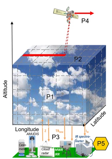
The scientific work in the C3SAR Research Unit is organized in five projects, which are illustrated in the figure below.
Project description
Project 1 provides high spatiotemporal and microphysically resolved cloud fields from state-of-the-art cloud resolved modelling. This will provide the data base to understand the variability of cloud properties relevant for radiative transfer and remote sensing. The modelling results will cover specific cloud regimes and cloud scenarios that have been extensively observed during recent field campaigns. Modelling results around field observations will bring the latter into a more complete context. The resulting cloud fields will be used for a variety of radiative transfer sensitivity studies with different degrees of complexity. These studies will systematically evaluate the role of cloud spatial and microphysical variability on transmitted and reflected radiative fluxes (for climate applications) and radiances (for remote sensing applications) and thus provide the basis for cloud-regime-resolved cloud-radiation correlations.
Project 2 extends and critically evaluates the analyses of Project 1 to different cloud regimes by means of statistical cloud reconstructions and 3d radiative transfer. Cloud reconstructions will be performed by combining vertically resolved cloud properties from active space-borne sensors with horizontally resolved cloud properties from passive imagers. Thanks to the vast amount of available satellite data, regime-dependent 3D cloud properties can be obtained. These properties serve as input to 3D radiative transfer models, thus providing empirical regime-resolved relationships between clouds and radiation. These relationships are applicable to both climate modelling and global remote sensing.
In Project 3, an empirical cloud-radiation correlation is established, that is based on long term vertically resolved cloud and radiation measurements at the Lindenberg Observatory of the DWD. In addition, in-situ measured broadband and spectral irradiance will be used for radiation closure. Thanks to the availability of long-term observations at Lindenberg, statistically robust cloud-radiation correlation can be inferred and compared to those from a modelling perspective in Project 1 and a satellite perspective in Project 2. In addition, these measurements are extended during a three-month measurement-campaign in Lindenberg in summer 2026. There, also the spectral radiance will be measured by the advanced multidirectional spectroradiometer AMUDIS, which was developed in Hannover.
Based on improved cloud-radiance correlations as achieved in the Projects 1, 2 and 3, Project 4 will revisit satellite-based cloud remote sensing with account for 3d effects in calculating cloud and irradiance products. Project 4 will establish new proxies for cloud inhomogeneity for different cloud regimes. Inhomogeneity corrections of satellite-based cloud and radiation products will be applied.
Project P5 is based on long-term observations in Lindenberg in combination with the field campaign at the Lindenberg Observatory. At the C3SAR-field-campaign, the suite of available instruments at the observatory will be expanded by measurements of spectral radiance, performed with AMUDIS. Furthermore, a network of pyranometers will be deployed. These ground-based measurements are combined with satellite-based observations and models to obtain the most complete set of co-located data sets on cloud and radiation properties. This will allow to test the cloud-radiation-dependency developed by this research unit. Project 5 will also contain data from new satellite sensors on Board MTG and EarthCARE that will obtain the physical and radiation properties of clouds from space.
TROPOS is responsible for the coordination of C3SAR. Prof. Andreas Macke is the speaker of the Research Unit and Dr. Jörg Schmidt works as scientific coordinator of C3SAR at TROPOS.
Besides that, TROPOS is involved with seven further scientists in C3SAR, among this, three PhD candidates. Thereby, TROPOS contributes significantly to Projects 1, 2, 4 and 5.