Measurement of air quality parameters with a new type of drones - Air-Q-Drone
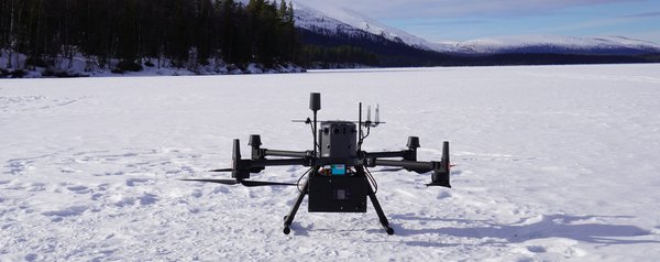
In the Air-Q-Drone project, a commercial drone is equipped with measurement technology for detecting particulate air pollutants such as PM 10, PM2.5, and ultrafine particles. It is operated and characterized in flight under highly variable atmospheric conditions such as temperature, humidity, and wind. In contrast to previous systems, the entire range from 10 nm to 10 μm is covered here. Previous projects were often only able to estimate the range below 300 nm, which resulted in considerable uncertainty in the measurements.
The Air-Q-Drone project is part of a DFG priority program (SPP 2433 - Measurement Technology on Flying Platforms), which addresses the ever-increasing demand from society and industry for measurement and sensor systems for flexible and mobile measurement systems. For example, to understand the impact of unpredictable environmental influences on buildings, facilities, and plants, and to carry out maintenance tasks. Of particular interest is the space close to the ground up to approx. 500 m, which humans inhabit, intensively design, and cultivate. This always raises the question of which measurement system carrier can be used to take fast, resource-saving, and high-quality measurements. And how can measurements be taken at great heights and in hard-to-reach places, such as offshore wind turbines, without exposing people to danger?
The priority program therefore aims to explore new measurement capabilities and clarify the measurement quality of measurement technology on flying platforms. It is a unique consortium of 19 interdisciplinary research projects that will lay the foundations for future mobile measurement systems.
In fact, uncrewed aerial vehicles (UAVs), or drones, offer untapped potential for use as mobile measurement system carriers because civilian drone technology is still very young compared to other mobile systems and is undergoing continuous technological advances. A crucial point here is that, to date, it has been more common to extract qualitative information from image data, particularly using artificial intelligence, while there are hardly any quantitative measurements with measurement uncertainties. However, if, for example, a statement is needed about the load-bearing capacity of a damaged bridge or the structural integrity of the rotor blade of a wind turbine, only measured values with uncertainty specifications can lead to a reliable statement. This involves dealing with tightly limited resources in terms of weight, installation space, energy, and time, and drone- and environment-related, sometimes unpredictable influences interfere with the measurement. The joint research efforts therefore focus on clarifying and minimizing the measurement quality achievable for various measured variables and on a standardized evaluation of measurement quality in connection with the resources used.