Due to their dense development and the large extent of sealed surfaces, urban spaces exert a significant effect on local meteorological processes and microclimatic conditions, which subsequently also influence the spread and distribution of urban air pollutants. Important effects are the heat island effect, a deviation from the usual logarithmic wind profile, the increase in the urban boundary layer height, as well as generally increased turbulent transport processes within the urban boundary layer. For example, the urban heat island effect contributes significantly to a higher health burden of the urban population during heat waves, which makes an important area of application of urban modelling also in the investigation and planning of green areas and tree populations to alleviate this effect. Buildings play an important role in urban air quality in that they can partially hinder or locally increase the spread of emissions, which leads to a spatially very variable pollution load. At TROPOS, these effects are investigated on different scales by means of suitable model studies. For this purpose, different models and procedures are available as tools, some of which are also developed at TROPOS.
Regional model COSMO-MUSCAT with city parameterization
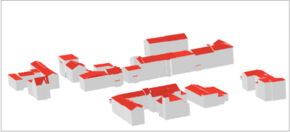
3D representation of a building selection of the city model for Leipzig.
The regional model COSMO-MUSCAT [Wolke et al., 2012] has been used for many years in air quality modelling at TROPOS. By implementing the city parameterization DCEP (Double Canyon Effect Parameterization) [Sebastian Schubert, HU Berlin] in COSMO-MUSCAT, the scope of its application could be extended to urban areas. DCEP is based on a simplified urban geometry in which street canyons are approximated by means of double canyon elements, which take up a certain percentage of the model cell depending on the degree of sealing. The horizontal orientation as well as the heights of the street canyons or canyons are described with a statistical distribution, which is determined on the basis of a geometric 3D building model for the respective city. The average street and building widths are also calculated for each discrete spatial orientation on the basis of this data.
Building heights for the complete city model for Leipzig with approx. 100,000 building units, with the COSMO MUSCAT grid.
DCEP calculates a physical model for the present double canyon structure, which includes, among other things, a detailed radiation transfer and a heat conduction equation for urban areas. An important prognostic quantity is the surface temperature, which subsequently determines the parameterization of the sensitive heat flow into the atmosphere. Similarly, the parameterization of impulse flows is carried out by friction effects of the buildings, as well as additional production terms for the subgrid-scale turbulent kinetic energy, whereby the turbulent mixing length is also adapted to the average building height.
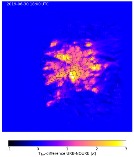
In simulations, the heat island effect together with the intensified turbulent transport processes usually cause a significant reduction in ground-level air pollutant concentrations within urban areas compared to simulations that do not take such effects into account.
-
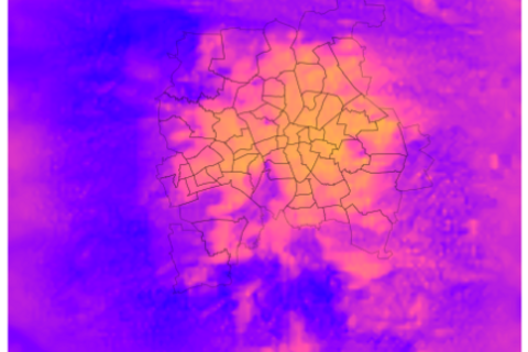
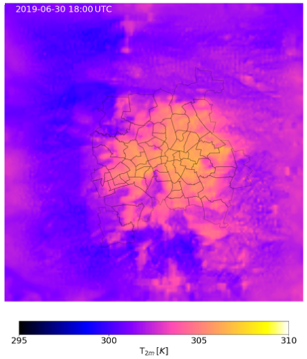
Simulated 2m temperature for the city of Leipzig with DCEP.
-
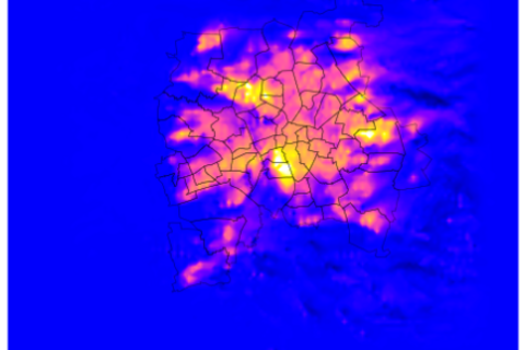
Heat island effect represented by difference to a control run without DCEP.
Urban Dispersion Modeling
Air quality simulations on a regional to urban scale, for example with the chemical transport model COSMO-MUSCAT, are representative of the urban background. However, much higher horizontal resolutions are required for a realistic inner-city distribution of air pollutant concentrations, especially in traffic-related areas. In addition, the parameterization of the building effects is no longer sufficient. The urban structures must be realistically embedded in a detailed flow model. To investigate air pollution and relevant processes on the urban microscale, the new City-scale AIR dispersion model with DIffusive Obstacles (CAIRDIO) [Weger et al., 2021] is being developed at TROPOS as a downscaling method. The new urban climate model PALM-4U is also used for the application-oriented modelling of urban air quality.
Microscale city dispersion model CAIRDIO
CAIRDIO further develops an approach in which buildings are represented as diffuse flow obstacles. This allows the horizontal grid width to be selected more flexibly, so that computing time can be saved or larger areas can be selected in order to simulate entire cities with considerable detail.The spatial discretization of the diffuse buildings is carried out by means of a finite volume method, whereby the computational grid is Cartesian, but the effective cell volumes and exchange surfaces between the grid cells are limited by buildings. The effective cell volumes result directly from the Cartesian volume minus the building volumes contained in the respective grid cell under consideration. Due to the effective exchange surfaces, the blocking effects of the buildings on the flow in the respective spatial direction are taken into account, whereby a kind of integrative "bottleneck approach" is used here to also take into account buildings that are completely located within a grid cell. By formulating the prognostic flow equations in conservation form, the buildings thus have a direct influence on the exchange flows between the grid cells for the respective physical quantity obtained, such as the momentum.
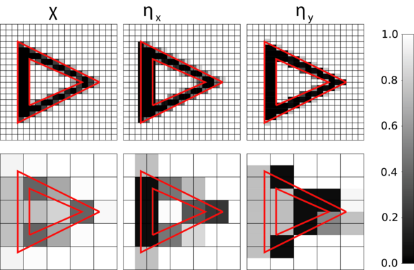
Horizontal discretization of a building with a triangular courtyard by means of a fine-meshed and a coarse-meshed grid based on the scaling factors for volume and cell areas (shown for the x- and y-flow direction). In the diffuse case, the blocking effect of the building's front surfaces is retained despite the coarse-meshed grid.
The diffuse building approach was integrated into the new urban dispersion model CAIRDIO. CAIRDIO solves the flow equations either in the Boussinesq or anelastic approximation and uses spatially interpolated results of a mesoscale model application with COSMO-MUSCAT as boundary values for a realistic meteorology. Furthermore, the temperature and specific humidity of surfaces can also be used from mesoscale simulation by means of a special reconstruction method. Thus, the corresponding surface flows for a realistic boundary layer dynamics can be parameterized using the Mokin-Obukhov theory.
The CAIRDIO model has already been successfully validated with wind tunnel experiments and is currently being tested in combination with the mesoscale air quality model COSMO-MUSCAT for the simulation of inner-city soot distribution in Leipzig.
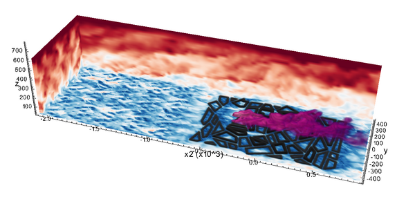
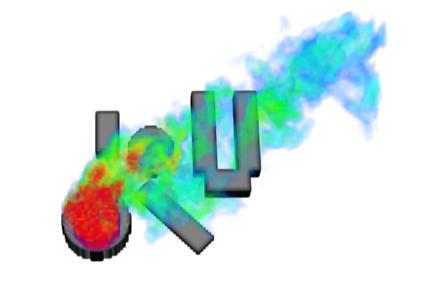
Numerical simulation of a wind tunnel experiment for tracer transport of a point-shaped source within an urban boundary layer flow with neutral stratification. The tracer cloud is shown in purple.
In the time average, the simulated tracer concentration shows a very good agreement with the measurements, which are represented by circles.
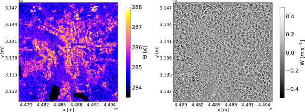
Simulation of a convective boundary layer over the city of Leipzig during daytime, which is induced by a positive sensitive heat flow, especially from the heated urban surfaces. On the left is the potential temperature, on the right the vertical speed 10m above ground. The organization of convection takes place in cells, which, however, are weakened or completely absent over the cool water surfaces.
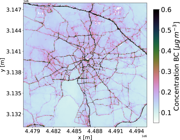
The corresponding simulation of the soot concentration shows a rapid decrease with increasing distance from the roads, which indicates an efficient vertical transport by convection.
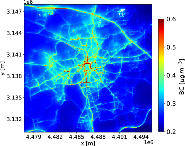
Inner-city distribution of the soot concentration in Leipzig at 40m horizontal resolution, now averaged over a simulation period of 2 days.
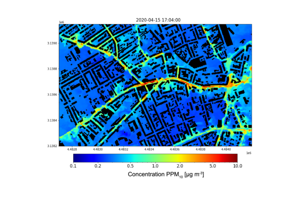
Simulation of the Leipzig-Lindenau district at a resolution of 5m. Finer details can now be seen, such as turbulence and effects caused by buildings. The busy Lützner Straße is also clearly visible due to increased primary particulate matter concentrations.
Urban Climate Model PALM-4U – Leipzig Setup
TROPOS also uses the new urban climate model PALM-4U [Maronga et al., 2015; Resler et al., 2017] for downscaling purposes and to investigate the relationships between urban climate and air quality. PALM-4U is being developed as part of the Germany-wide research project "Model-based Urban Planning and Application in Climate Change" (MOSAIK) in the BMBF program "Urban Climate in Transition - [UC]²". The model is based on the PArallelised Large-eddy simulation Model (PALM), which was originally developed by the Institute of Meteorology and Climatology (IMUK) at Leibniz Universität Hannover. PALM-4U is equipped with special components suitable for describing the various characteristics of the urban environment and includes a number of tools and diagnoses for urban planning, as well as scientific research. The model system PALM-4U is a freely accessible software whose components are further developed by the MOSAIK consortium. It is suitable for simulations of large cities up to 2,000 km² in size and grid-resolved buildings on a Cartesian grid with grid widths up to 1 m and below. Model components that are particularly relevant for research at TROPOS include sophisticated representations of rural and urban surfaces and radiation transfer within the urban boundary layer. In addition, there is the possibility of nesting in realistic mesoscale weather model data, a chemistry module for the transport and conversion of reactive gas species, simple photolysis parameterization, a sectional aerosol module, as well as descriptions of the dry deposition of gases and particles.
For Leipzig, there is a PALM-4U model environment for building-resolution simulations for a part of the city that extends between the Friedenspark and the Lene-Voigt-Park in the southeast of Leipzig. The model area currently has a size of 1.5 km x 1.5 km with a horizontal grid width of 5 m and 42 vertical layers of 2 m. The configuration uses very detailed information on building geometry, vegetation and road types, and road traffic emissions. The model is dynamically driven by the regional COSMO-D2 analysis of the German Weather Service (DWD).
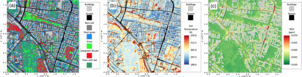
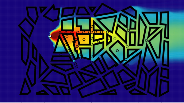
Building-resolving PALM-4U simulations for a model area between Friedenspark and Lene-Voigt-Park' in the southeast of Leipzig. Shown are (a) vegetation and buildings, (b) soil temperature and (c) near-surface NO2 concentration for October 18, 2019, 15:00 UTC.
Initial model results for the hot summer and autumn days of recent years 2018/2019 show a great variability of surface roughness and radiation fluxes throughout the area, which is due to the mixed development structure including the adjacent parks with trees and lawns. As reproduced by PALM-4U, these features lead to strong differential warming and near-surface temperature gradients between green and built-up areas, causing the turbulent flow situation expected for this urban environment. Urban flow patterns influence the spread of air pollutants such as NO2. Hotspots of traffic emissions and delayed wind flow in street canyons lead to high concentrations in some busy, narrow streets, while air pollution is significantly lower in the larger parks and backyards.