-
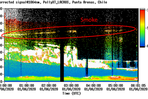
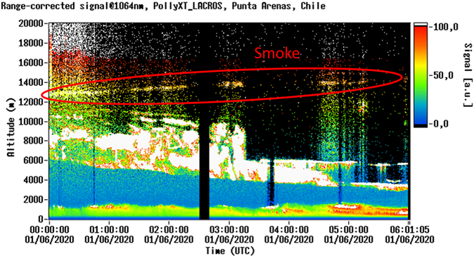
Current lidar measurements show a layer of dust over Punta Arenas in the early morning of 6 January 2020 at an altitude of about 12-13km - visible as a white layer in the picture. Source: Holger Baars, TROPOS
-
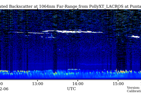
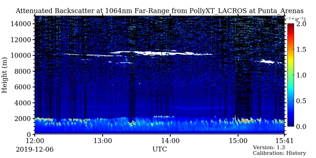
The lidar measurements show how at noon on 6 December 2019, at an altitude of about 3-4km, a layer of dust passes over Punta Arenas - shown in the image as a white layer. Source: TROPOS / http://picasso.tropos.de/archive_link/recent_plots_new/PollyXT_LACROS/2019/12/06/2019_12_06_Fri_LACROS_12_00_01_ATT_BETA_1064.png
-
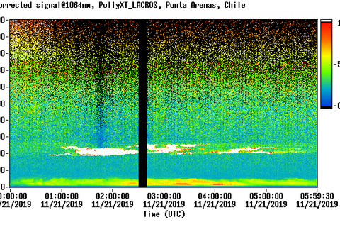
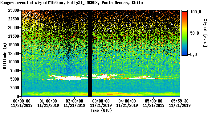
The lidar measurements show how in the evening of November 20th from about 23 h local time at an altitude of about 5000 m a dust layer is moving over Punta Arenas as a white layer. Source: TROPOS / http://polly.rsd.tropos.de/?p=bilder&lidar_id=244&lambda=3&Jahr=2019&Monat=11&Tag=21&Ort=24#bildanker
-
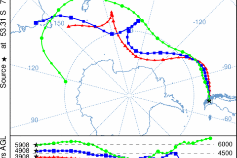
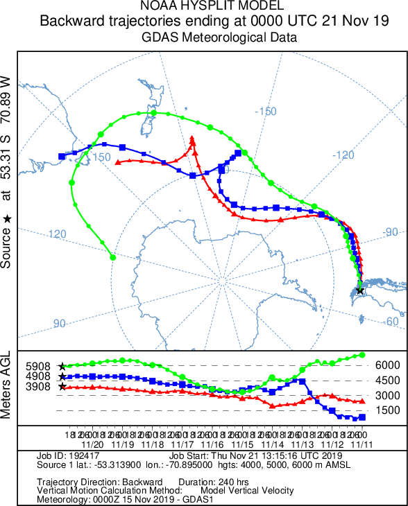
The backward trajectories show how the air masses have moved from southeast Australia across the South Pacific on the edge of Antarctica to Punta Arenas. Source: Martin Radenz / TROPOS
-
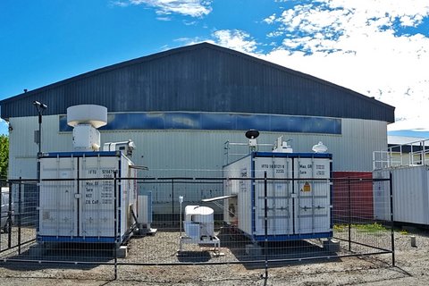
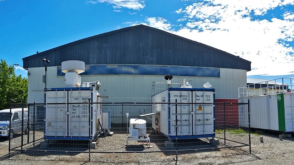
dacapo-PESO in Punta Arenas (Chile) in summer. Photo: Patric Seifert, TROPOS
-
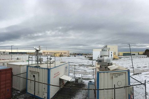
dacapo-PESO in Punta Arenas (Chile) in winter. Photo: Martin Radenz, TROPOS
Australian forest fires are felt as far away as Chile
In 10 days from Australia to Tierra del Fuego - that's how long the smoke trail of the catastrophic forest fires on Australia's southeast coast across the Pacific took. Scientists from the Leibniz Institute for Tropospheric Research (TROPOS), the University of Leipzig and Magellan University (UMAG) have now been able to prove once again that the smoke blows more than 10,000 kilometres as far as South America. Currently, the lidar in Punta Arenas shows a thin layer of dust at an altitude of almost 6 kilometres. One month before such a layer was observed at a height of 10 kilometres. The lidar measurements of 21 November 2019 have already been evaluated. They show a dust layer at an altitude of 5 kilometres, which could be identified as smoke from biomass combustion based on the reflections. Since the air at the southern tip of America is otherwise very clean, this type of air pollution was immediately noticeable. The backward trajectories of the air movements show that these air masses were in Australia about 10 days ago and then moved east past New Zealand and Antarctica. This proves that the smoke from the whale fires in Australia travels as far as South America and also influences the clouds and climate there.
The measurements of dust in the atmosphere using lidar laser pulses from the ground, which have been running for a year in Punta Arenas at the southern tip of Chile as part of the DACAPO-PESO measurement campaign, thus confirm satellite images, modelling and aircraft measurements:
The satellite images of November 13th, reported by the British New Scientist, show that the air pollution from the fires in New South Wales and Queensland extends far into the Pacific Ocean. Researchers from the European Centre for Medium-Range Weather Forecasts (ECMWF) in Reading, Great Britain, had discovered a plume of carbon monoxide and aerosols which led across the Pacific to South America. NASA subsequently published an animation of its GEOS model on Twitter, showing how soot from Australia travels halfway around the world in November.
The German research aircraft HALO also measured very high levels of carbon monoxide in the atmosphere during its "SouthTRAC" mission between Tierra del Fuego and Antarctica on 12 November, the German Research Foundation (DFG) also reported on Twitter, quoting researchers from the University of Mainz.
The proof now is not the first evidence of forest fires from Australia in South America. In 2009/10, the team had already carried out measurements in Punta Arenas and, together with the U.S. Naval Research Laboratory, evaluated data from the satellite lidar CALIPSO and the solar photometer network AERONET. At that time too, layers of air at an altitude of 5 to 12 km could be observed, which had transported smoke particles from Australia across the Pacific Ocean. The evaluation of the ALPACA measurement campaign will appear in May 2019 in the Open Access journal Atmospheric Chemistry and Physics (ACP) and is probably the first to describe this phenomenon using measurements from the ground and from space. On satellite images from 2006 and 2009, other research groups had already followed the trail of forest fires across the South Pacific. During the so-called "Black Saturday bushfires" in February 2009, a total area of around half a million hectares burned in the state of Victoria around Melbourne. Nearly 200 people lost their lives in the fires. The fires at the time were considered the biggest fire disaster in Australia. However, with over 6 million hectares and 25 deaths, the current forest fire season is already one of the worst in a decade.
The transport of smoke particles from vegetation fires from continent to continent is not uncommon, but is apparently often overlooked due to lack of measurements. As early as 2012, scientists from TROPOS and the Brazilian universities of Sao Paulo, Diadema and Manaus had already documented smoke from Africa over the Amazon in the journal Geophysical Research Letters, which they were able to prove by long-term measurements with a LIDAR system from Leipzig.
The global atmospheric network PollyNet could help to close such observation gaps in the future. PollyNet is a network of light radars that use laser beams to explore the atmosphere from the ground. Its measurements contribute to the European research infrastructure ACTRIS, which studies aerosols, clouds and trace gases. It is coordinated by the Leibniz Institute for Tropospheric Research (TROPOS) in Leipzig. PollyNet stations already measure dust in the atmosphere continuously by laser in Finland, Germany, Greece, Poland, Portugal, Tajikistan and South Korea. Further stations are planned in Cyprus and on the Cape Verde Islands. Tilo Arnhold
Publication:
Foth, A., Kanitz, T., Engelmann, R., Baars, H., Radenz, M., Seifert, P., Barja, B., Fromm, M., Kalesse, H., and Ansmann, A.: Vertical aerosol distribution in the southern hemispheric midlatitudes as observed with lidar in Punta Arenas, Chile (53.2° S and 70.9° W), during ALPACA, Atmos. Chem. Phys., 19, 6217–6233, https://doi.org/10.5194/acp-19-6217-2019 , 2019.
Links:
Current lidar data from Punta Arenas, Chile:
http://picasso.tropos.de/calendar/lidar/244?&individual_page=2020
http://polly.tropos.de/?p=lidarzeit&Ort=24
Smoke from Australia's bushfires has spread to South America
#Australien #Buschbrände Forschungsflugzeug HALO misst enorme CO-Werte zwischen Antarktis und Feuerland!
https://twitter.com/dfg_public/status/1197545880368418816
HALO-Kampagne „SouthTRAC“
https://www.pa.op.dlr.de/southtrac/
https://www.ipa.uni-mainz.de/2019/08/23/southtrac-2019/
Campaign „DACAPO-PESO“
https://dacapo.tropos.de/index.php
Black Saturday bushfires / Buschfeuer in Victoria 2009
https://en.wikipedia.org/wiki/Black_Saturday_bushfires
Bushfires in Australia
https://en.wikipedia.org/wiki/Bushfires_in_Australia
Afrikas Rauch dringt bis nach Südamerika vor