AEOLUS-DISC
Allgemeine Projektbeschreibung
Das Aeolus DISC (Data, Innovation, and Science Cluster) ist ein internationales Expert*innenkonsortium aus Forschungseinrichtungen, das sich der Earth-Explorer-Mission Aeolus der Europäischen Weltraumorganisation ESA widmet. Der Aeolus-Satellit war von 2018 bis 2023 im Einsatz und trug das erste UltraViolett-Doppler-Wind-Lidar im Weltraum: das Atmospheric LAser Doppler INstrument (ALADIN). Obwohl die Mission ursprünglich zur globalen Messung der Windverhältnisse auf der Erde entwickelt wurde, lieferte Aeolus auch wertvolle Daten zur Aerosolprofilierung bis in eine Höhe von 30 km. Dabei wurde die Fähigkeit zur Hochspektralauflösung (HSR) von ALADIN optimal genutzt. Dies ermöglicht eine Charakterisierung der optischen Eigenschaften von Aerosolschichten weltweit, auch über Ozeanen und in tropischen Regionen, in denen Lidar-Messungen bisher kaum möglich waren.
Im Rahmen der ESA-Datenverarbeitungskette und des Qualitätsrahmens decken die Beiträge von Aeolus DISC eine Vielzahl an Themen ab – von instrumentellen Aspekten und der Wechselwirkung zwischen Laser und Atmosphäre bis hin zu Flugzeugmesskampagnen. Dazu gehören auch Wartung und Weiterentwicklung der Aeolus-Prozessoren für Aerosol- und Wolkenprodukte sowie Windprodukte. Einige zentrale Aufgaben des Aeolus DISC sind:
- Verfeinerung der Algorithmen und Überwachung der Instrumentenleistung
- Qualitätsbewertung und Validierung der Aeolus-Aerosol- und Windprodukte
- Unterstützung von In-situ-Messkampagnen sowie Auswertung und Zusammenfassung der Kalibrierungs- und Validierungsergebnisse (Cal/Val)
Die Aeolus-Mission hat die wissenschaftlichen Erwartungen übertroffen und ihre geplante Lebensdauer im Orbit deutlich überschritten. Die operative Phase endete am 28. Juli 2023 mit mehreren letzten Meilensteinen: Unter anderem wurden End-of-Life-Experimente durchgeführt, die zukünftige Lidar-Missionen wie EarthCARE oder Aeolus-2 unterstützen sollen. Zudem wurde der erste kontrollierte Wiedereintritt eines ESA-Erdbeobachtungssatelliten erfolgreich begleitet.
Seitdem konzentriert sich die neue Phase der Mission darauf, der Atmosphärenforschungsgemeinschaft hochwertige Aerosol- und Windprodukte zur Verfügung zu stellen, mit dem Ziel, neue Anwendungen in der Aerosolforschung zu ermöglichen und die positiven Effekte der Mission auf die numerische Wettervorhersage weiter zu stärken.
Beiträge vom TROPOS
Im Rahmen des Aeolus-DISC-Konsortiums lieferte TROPOS kontinuierlich Referenzmessungen weltweit mit den PollyNET-Bodenstationen zur Validierung der Aerosol- und Wolkenprodukte der Level-2A (L2A) sowie der Windprodukte der Level-2B (L2B). Damit trug TROPOS von Beginn bis zum Ende der Mission zur Bewertung der Algorithmenleistung bei. Zudem ist TROPOS an der Weiterentwicklung des L2A-Produkts zu optischen Aerosoleigenschaften beteiligt und unterstützt wissenschaftliche Anwendungen auf Basis des erneut prozessierten Aeolus-Datensatzes. Diese Arbeit umfasst die Vorbereitung von Prozessorkomponenten sowie die Aktualisierung technischer Dokumentationen.
Dr. Sebastian Bley und Promovierender Dimitri Trapon sind die zentralen Ansprechpartner.
Sebastian Bley koordiniert als wissenschaftlicher Ansprechpartner die Unterstützungsaktivitäten für die Cal/Val-Teams. Er verfügt über Expertise in der Wolkenfernerkundung sowie in der Nutzung von Synergien zwischen satellitengestützten Bildsensoren und Lidar-Instrumenten.
Dimitri Trapon ist verantwortlich für die Pflege und Weiterentwicklung des L2A-Prototyp-Prozessors zur Bestimmung optischer Eigenschaften von Aerosolen und Wolken. Er bringt tiefgehende Kenntnisse des Aeolus-Aerosol-Retrieval-Algorithmus sowie im Monitoring der Instrumentenleistung mit.
TROPOS leistet damit einen wichtigen Beitrag zum Erfolg der Mission – basierend auf der langjährigen Erfahrung des Instituts in der Messung und Klassifikation atmosphärischer Partikel mithilfe von Lasern mit mehreren Wellenlängen. Das Fachwissen der beiden Arbeitsgruppen Clouds, Aerosols and Radiation (CAR) sowie Lidar Applications (LA) aus der Abteilung Fernerkundung atmosphärischer Prozesse (RSD) wird gezielt eingesetzt, um die Qualität der Aeolus-Produkte zu bewerten und ihre wissenschaftliche Relevanz für die Aerosolforschung zu stärken.
Die Aeolus-Datensätze sind im ESA MAAP Explorer unter folgender Adresse verfügbar: https://explorer.maap.eo.esa.int
Weitere Informationen zu Level 2A Daten (optische Eigenschaften von Aerosol und Wolken) und zu Level 2B Daten (Wind) finden Sie unter ESA eogateway:
https://earth.esa.int/eogateway/catalog/aeolus-l2a-products und https://earth.esa.int/eogateway/catalog/aeolus-l2b-products
Informationen zum Projekt
Finanzierungsinstanz: Europäische Weltraumorganisation (ESA)
Förderungsnummer:
TROPOS AEOLUS Kostenträger R10051200
ESA-Vertrag Nr. 4000126336/18/I-BG
(Aeolus Data Innovation and Science Cluster (DISC) – Phase E2)
ESA-Untervertrag Nr. D/553/67342749 To ESA-Vertrag Nr. 4000144330/24/I-AG
(Aeolus Data Innovation and Science Cluster (DISC) – Phase F1)
Offizielle Projektseite
Weitere Links
Beispielhafte Messfälle
Kalifornischer Waldbrandrauch über Europa
Anfang September 2020 wurden massive Rauchfahnen, die durch schwere Waldbrände in Kalifornien entstanden waren, ostwärts über die Vereinigten Staaten transportiert. Signaturen dieses Rauchs in der oberen Troposphäre konnten über mehr als eine Woche hinweg von Aeolus beobachtet werden (Abb. 2a), während des großräumigen Transports über den Atlantik. Wichtige optische Eigenschaften wie der Extinktionskoeffizient oder das Verhältnis von Extinktion zu Rückstreuung sowie deren zeitliche Entwicklung wurden von Aeolus gemessen. Die hohen Werte in den L2A-Produkten, abgeleitet mit dem Standardkorrekturalgorithmus (SCA) und der Maximum-Likelihood-Schätzung (MLE), deuten auf dunkle Partikel hin und liefern weitere Hinweise auf Biomasseverbrennung.
Rauchreste wurden mit bodengebundenen Mehrwellenlängen-Raman-Polarisations- und Wasserdampf-Lidar-Messungen (PollyXT) über Westeuropa verglichen (Abb. 2b). Diese zeigten eine Zunahme des rückgestreuten Lichts (Abb. 2c) und bestätigten so den Transport des Rauchs über den Atlantik hinweg (Baars et al., 2021).
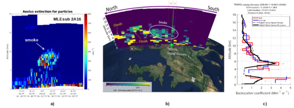
Abbildung 1: Aeolus-Profil über den USA am 12. September 2020 mit dem MLEsub-Extinktionskoeffizienten für Partikel, bezeichnet als Baseline 2A16 (a). Visualisierung des Aeolus-Überflugs über Europa am 11. September 2020 mit ESA VirES (https://aeolus.services/) (b) und Vergleich des SCA-Rückstreukoeffizienten für Partikel mit PollyXT (c).
Stratosphärische Aerosole durch den Vulkanausbruch von Hunga Tonga
Am 15. Januar 2022 stieß der Hunga-Tonga-Vulkan im Südpazifik eine große Menge an Partikeln aus, die in die Stratosphäre eindrangen. Dank der Flexibilität von Aeolus wurde der Messbereich auf eine Höhe von bis zu 30 km eingestellt, und eine der vulkanischen Aerosolfahnen wurde beobachtet, wie sie nach Westen abdriftete. Signaturen stratosphärischer Aerosole waren im Near Real Time (NRT) L2A-Produkt mit der Bezeichnung Baseline 2A13 deutlich sichtbar. Die co-polare abgeschwächte Rückstreuung für Partikel, die auf einer feineren horizontalen Skala gemessen wurde (~ 6 km mit den Einstellungen vom Januar 2022), ergab Mittelwerte in der Größenordnung von ~2-3 bis ~3-3 km -¹ sr -¹ für das frische Aerosolfilament, das in ~ 25 km Höhe beobachtet wurde (Abb. 3b). Es wurde erfolgreich mit dem parallelen Signal verglichen, das aus den CALIOP/CALIPSO-Satellitenbeobachtungen der NASA abgeleitet wurde (Abb. 3c), und zwar für Bahnabschnitte mit minimalem Geolocation-Offset über dem Pazifik (Abb. 3a). Die Partikel-Lidar-Verhältnisse, die durch den MLE-Algorithmus auf einer gröberen horizontalen Beobachtungsskala von ~90km (z.B. rechts) ermittelt wurden, erreichten ~50sr +/- 20sr, was im Vergleich zur Literatur gültig war. Die zonalen Breitenmittelwerte der wichtigsten optischen Parameter sind vielversprechend, um die globale Verteilung der Aerosolschicht bei der Umrundung der Erde auf der Südhalbkugel zu beurteilen.
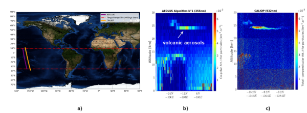
Figure 2 : Aeolus- und CALIOP-nächstgelegene Überflüge über dem Pazifischen Ozean am 31. Januar 2022 (a). Aeolus SCA ko-polares partikelfraktioniertes abgeschwächtes Rückstreusignal bei 355 nm (b). CALIOP/CALIPSO ausschließlich paralleles gesamtes abgeschwächtes Rückstreusignal bei 532 nm (c).